|
|
|
| Subscriptions click here for 20% off! | E-Mail: info@rangemagazine.com |

 |
Don't accept the lies, By Tim Findley |
|||||||||||||
|
I’ll tell you something that surprises everybody,” begins San Juan County Personnel Director Ed Scherick. “Out of all these types of photographic studies that have been done over the years, there is only one study that shows conclusively that the land is worse today than it was 50 or 100 years ago. “That study is Yellowstone National Park.” Scherick should know. For more than 15 years, he was the BLM superintendent for this region, and accustomed to the familiar cries of “overgrazing” and land abuse by those with agendas of their own. Before moving on to become San Juan County, Utah’s, “interface” with public lands, he had seen many such photographic comparisons as that which he ordered in his own county. The results were always the same–at worst, the lands seemed unchanged, but in almost every case, vegetation and soil erosion showed remarkable improvement over the past half-century. |
||||||||||||||
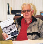
| For 15 years, Ed Scherick was BLM superintendent accustomed to the cries of “overgrazing.” He knows that’s not true. Photos, right, are from “A Photographic History of Vegetation and Stream Channel Changes in San Juan County, Utah,” by Earl Hindley, Dr. Jim Bowns, Ed Scherick, Paul Curtis and Jimmy Forrest. | ||||||||||||||
|
“Basically in the last 10 years especially, federal land agencies have gotten away from the principles of resource management. They’ve taken management out of their vocabulary and replaced it with ‘preservation’ and all these non-use topics,” says Scherick. “They only want to hear one side.” Almost instantly after leaving his federal job, Scherick found himself in a confrontational condition with even some of his own former employees, attuned since court decisions in 1976 to hear environmentalists first. As a resource specialist in his time, he was never trained in politics, but today he confronts people holding his old job who are political appointees. “They don’t have to support resource management,” he says. “They have to support political administrations.” But Scherick knew enough about “bio-diversity” schemes and pressures for wilderness to recognize the tactics aimed at his county. The photos alone didn’t block it, but with the support of his county commission, Scherick was able to point with clear evidence to a loss of some 60 percent of San Juan’s assessed value in the last decade because of blocks on oil and mineral exploration and impossible rules on resource use in general. County officials were not hesitant to tell the San Juan citizens of their concerns. Publicly, without threats, they let it be known they would resist however they could. Plans to stretch a monument into their county faded. “You can’t ask the federal people for help out here anymore,” he says. “You’ve got to help yourself.” |
||||||||||||||
 |
||||||||||||||
 |
||||||||||||||
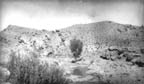
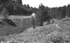
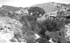
| ABOVE: Lower Mill Creek, left, in 1926. Maverick Point, right,
in 1957. BELOW: The same areas in 1999 and 1998 after grazing and recreational use. |
||||||||||||||
 |
||||||||||||||
 |
||||||||||||||
|
Related stories in this Special Section by Tim Findley: Making Monuments, Taking Towns Like Circling Buzzards, NGO's Wait
|
||||||||||||||
|
To Subscribe: Please click here or call 1-800-RANGE-4-U for a special web price Copyright © 1998-2005 RANGE magazine For problems or questions regarding this site, please contact Dolphin Enterprises. last page update: 04.03.05 |